Students get through the MP Board Class 9th Social Science Important Questions Unit 6 Map: Reading and Marking which are most likely to be asked in the exam.
MP Board Class 9th Social Science Important Questions Unit 6 Map: Reading and Marking
Very Short Answer Type Questions
Question 1.
What is a projection?
Answer:
Map projection is a systematic drawing of parallels of latitudes and meridians of longitude on a plane paper or cloth for the whole earth or a parts of it on a certain scale.
Question 2.
What is a map?
Answer:
A map is a representative of selected features of the whole, earth or a part of it on a plane surface, with conventional signs, drawn to a scale and projection so that each and every point corresponds to the actual terrestrial position.
Question 3.
What are conventional signs?
Answer:
There are certain standard signs and symbols to represent the topographical features on the map known as conventional signs.
Question 4.
What are the necessary elements of maps?
Answer:
There are certain points which are necessary in a geographical map called elements of a map. Without these elements a map is incomplete. Elements of a map are as follows:
(1) Direction, (2) Title and Sub-title, (3) Conventional signs.
![]()
Short Answer Type Questions
Question 1.
What is the importance of scale in a map?
Answer:
- A map cannot be drawn without a scale. It is not possible to draw a map of the whole earth’s surface on a paper without using a scale.
- By using a scale, topographical features are drawn on a plane paper in a map.
- A map is just an ordinary picture without a scale. In the absence of a scale, the distance between two places, on a map have no relevance since it is not actual.
Question 2.
Differentiate between a sketch map and a map. (2016)
Answer:
Maps present pictures of different parts of the earth. Oceans of the world can be represented through maps only whereas sketch maps are used to show the shape of a specific landmass only.
Question 3.
What are contour lines?
Answer:
Imaginary lines joining all the points of equal elevation or altitude above the mean sea level are called the contour lines. These lines are based on a detailed survey of heights of several places in an area. These lines are drawn at definite intervals such as 20, 50 or 100 metres above the sea level. It should always be in numbers ending with zero.
Question 4.
Show the following by conventional signs:
Temple (2009, 10, 12, 13, 14, 16), Mosque (2009, 11, 13, 15), Church (2009), State boundary (2011, 14), Metalled road (2011, 12, 14, 16), Non Metalled road (2015, 17), International boundary (2011, 15), Railway line (Broad gauge) (2011, 13, 15), Stream (2009), Well (2009, 12, 14, 17), River (2009, 13, 15, 17), Light house, Railway line (narrow or meter gauge) (2009, 12, 16), Idgah (2009), Pagdandi (2010), Pond (2010, 12, 14), District boundary (2010, 17), Garden (2010, 16), Tree (2013, 17), Settlement (2016).
Answer:
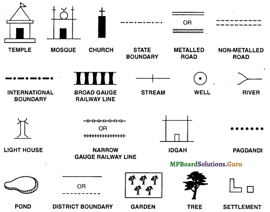
![]()
Question 5.
Write five importance of maps. (2017)
Answer:
Importance of Maps:
- Map is an art of providing a lot of information through signs in a short period of time.
- Study of places can be done sitting at home through maps, even of those places which are difficult to traverse (difficult terrains).
- Maps are the main tool of a geographer. Maps are very helpful for proper knowledge of geography. We get proper knowledge of the situation of a place, relief, climate, vegetation and human life of a place through maps.
- Map is a technique of representing a fact in an interesting manner in brief and at its proper place.
- Map is an authentic document to solve the boundary dispute between two adjacent countries.
Long Answer Type Questions
Question 1.
How many types of maps are there on the basis of utility? (2014)
Answer:
Maps drawn on the basis of utility may be classified into four parts:
- Physical Maps: On these maps relief features like mountains, plateau, plains, valleys etc. are shown by different colours such as brown, yellow and green according to contour lines.
- Political Maps: These maps show different countries their administrative units,
capitals, cities, transportation routes etc. Physical and cultural features are also sometimes seen in the background. - Distribution Maps: These maps display the distribution of elements found on the earth, continent, country or on any part of the country. Distribution of rainfall, temperature, pressure, crop production, minerals, flora, fauna, industries, trade, means of transport, population and tourist places etc. are shown on these maps.
- Special Maps: These maps are drawn for some special purpose and are used for giving specific information. These include many types of maps as: Relief maps, Geological maps, City planning maps, Weather maps, Ocean routes and Air route maps, Military maps etc.
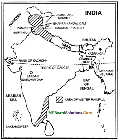
Question 2.
Show the following on an outline map of India:
(1) Areas of Winter Rainfall
(2) Kaziranga National Park, (2009)
(3) Bhakra-Nangal Dam
(4) Rann of Kachchh
(5) Tropic of Cancer, (2008, 09, 15)
(6) Arabian Sea, (2008, 09)
(7) Sardar Sarovar Dam. (2008, 09)
Answer:
Question 3.
Show the following on an outline map of India:
(1) Karakoram Range (2010), Satpura (2008, 09), Aravallis (2008, 13), The Himalayas (2012)
(2) Shiwalik Ranges (2010), Vindhya Ranges (2010), Satpura Ranges (2009, 10)
(3) Highest Peak of Himalayas (Mt. Everest) (2009)
(4) Chhota Nagpur Plateau, Malwa Plateau (2013)
(5) Ganga (2008,09,15), Tapti, Brahmaputra, Kaveri (2013), Narmada (2008, 09), Nilgiri Mountains (2012, 15)
(6) Thar Desert (2008, 09)
(7) Lakshadweep (2013).
Answer:
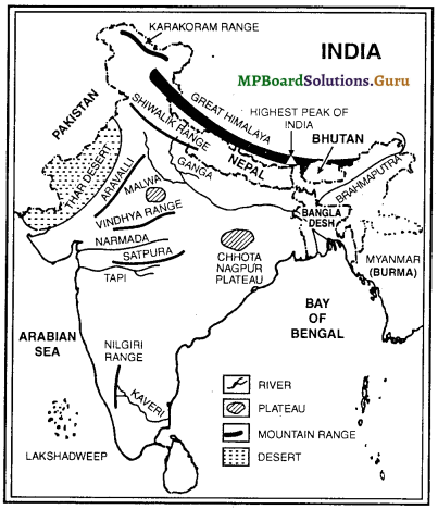
![]()
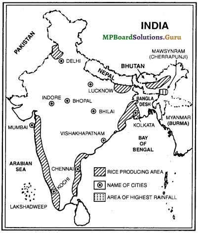
Question 4.
Show the following on the given outline map of India:
(1) Delhi (2008, 09), Vishakhapatnam, Bhilai, Bhopal (2008, 09, 12, 15), Chennai (2009), Kochi, Indore, Lucknow, Kolkata and Mumbai (2008, 09, 13),
(2) Rice producing areas,
(3) Area of highest rainfall (Mawsynram/Cherrapunji),
(4) Bay of Bengal (2008, 09).
Answer:
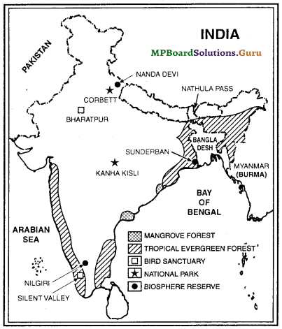
Question 5.
Show the following on the given outline map of India:
(1) Tropical Evergreen Forest and Mangrove Forest (2009),
(2) Bharatpur Bird Sanctuary and Silent Valley,
(3) Kanha Kisli (2015) and Corbett National Park (2008, 09, 15),
(4) Nanda Devi (2008), Nilgiri (2009), Sunderban, Biosphere Reserve, Nathula Pass (2012).
Answer: