Students get through the MP Board Class 9th Social Science Important Questions Chapter 8 Map: Reading and Numbering which are most likely to be asked in the exam.
MP Board Class 9th Social Science Important Questions Chapter 8 Map: Reading and Numbering
Short Answer Type Questions
Question 1.
What do you mean by representative fraction?
Answer:
Scale of a map is also indicated by a fraction called the representative fraction (R.F.) in which numerator is 1 and represents the distance on the map and the denominator represents the distance on the ground. R.F. is independent of any particular unit of measurement. By it one can judge distance on a map even if he is not familiar with the linear measurements of that country.
For example, if the R.F. in a map is stated to be 1 : 1,00,000 this means that one unit on the map represents 1,00,000 of the same unit on the ground. If this unit is centimetre, then 1 cm. On the map represents 1,00,000 cm on the ground, i.e., 1 cm represents 1 kilometre.
Long Answer Type Questions
Question 1.
What do you mean by map? What is its importance?
Answer:
A map is a representation of selected features of the whole earth or a part of it on a plane surface, with conventional signs, drawn to a scale and projection so that each and every point corresponds to the actual terrestrial position.
Importance of maps:
- Present day maps are used to settle the disputes of boundaries of the two countries.
- It is not possible to draw a map of the whole earth surface on a paper because finding a huge paper is difficult. It can be done by maps.
- By maps we can study about any land forms.
- We can find out more and more information by maps in short period of time. Thus, we can save the time also.
- By knowing the maps of resources of a place industrial development can be done.
- To explain the tourist industry and develop tourism we take the help of maps.
- We can get information about climate, vegetation, rivers and mountains.
- Maps of history, political science, geology are helpful in studies of other subjects.
- For military soldiers also get help from maps for attacking any country.
![]()
Question 2.
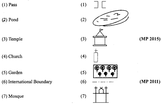
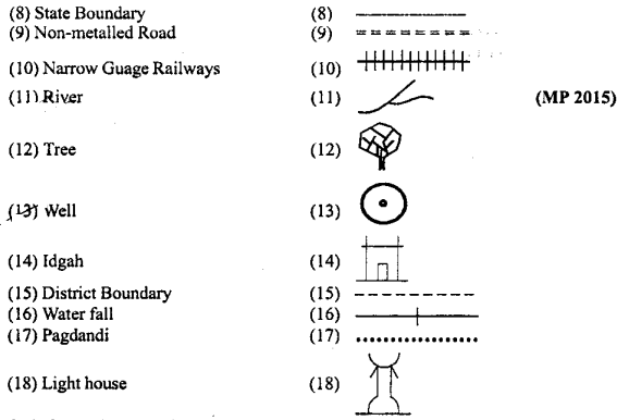
Write the conventional sign. (MP 2010, 12)
Answer:
Conventional sign:
Question 3.
Show the following on the map of India:
(1) Sardar Sarovar dam, (2) River Kaveri, (3) Annai mudi, (4) Jaipur, (5) Sundervan.
Answer:
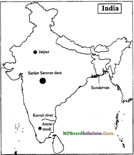
![]()
Question 4.
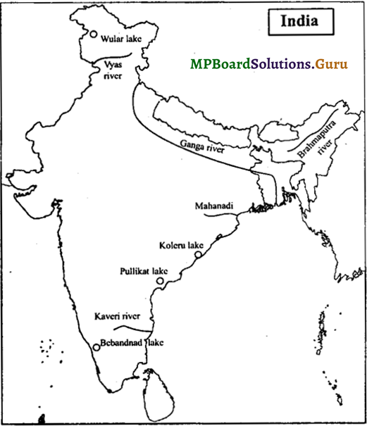
Show the following on the map of India:
(1) Kaveri river, (2) Mahandi, (3) Brahmaputra river, (4) River Vyas, (5) Wular lake, (6) Koleru lake, (7) Puliikat lake, (8) Bebandnad lake, (9) Ganga river. (MP 2009)
Answer:
Question 5.
Show the following on the map of India:
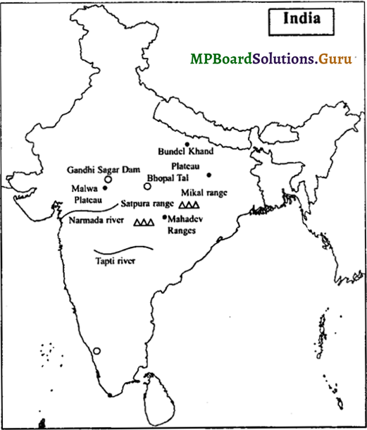
(1) Satpura range, (2) Mikal range, (3) Narmada river, (4) Tapti river, (5) Gandhi Sagar dam, (6) Bhopal Tal (7) Malwa Plateau (8) Mahadev ranges, (9) Bundel Khand Plateau. (MP 2010)
Answer:
Question 6.
Show the following on the map of India:
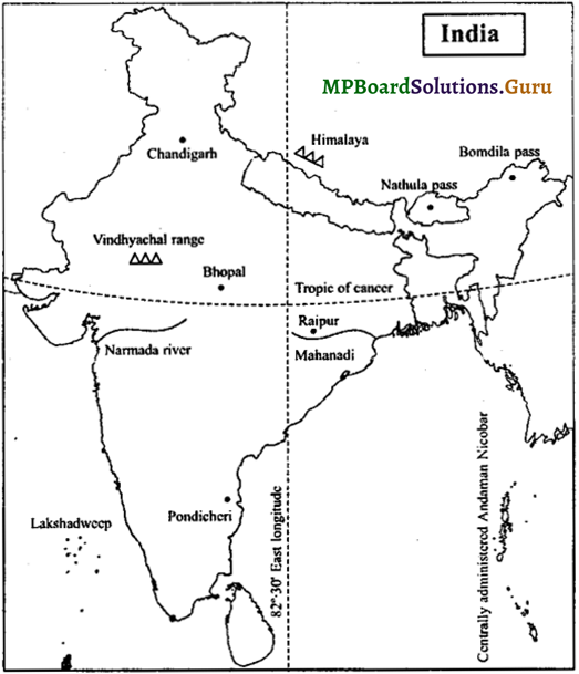
(1) Tropic of Cancer and 82° 30′ East longitude (MP 2015), (2) Centrally administered, Chandigarh, Pondicheri, (3) Bomdila, Nathuta pass, (4) Raipur, Bhopal, (5) Narmada river, Mahanadi, (6) Himalaya mountain, Vindhyachal range (2012), (7) Bhopal (2012).
Answer:
![]()
Question 7.
Show the following on the map of India:
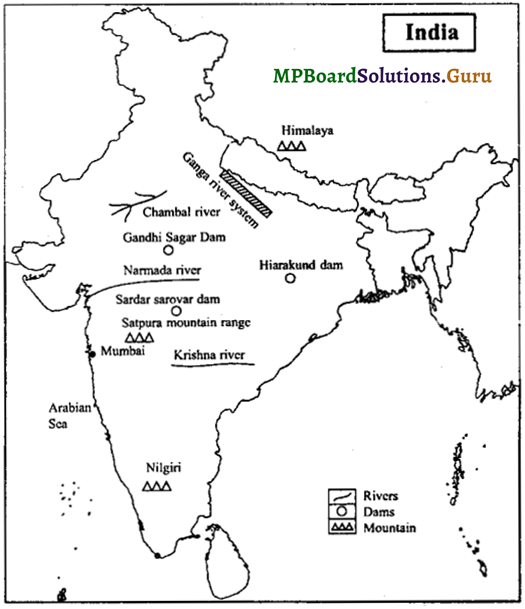
(1) Nilgiri (2012), (2) Narmada river, (3) Sardar sarovar dam, (4) Krishna river, (5) Hirakund dam.
Or
(1) Himalaya mountain (2) Satpura range, (3) Ganga river system, (4) Chambal river, (5) Gandhi sagar dam.
Answer:
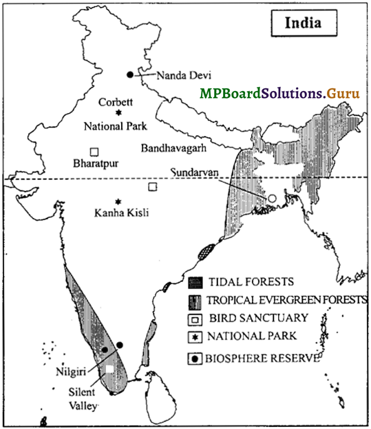
Question 8.
Show the following on the map of India:
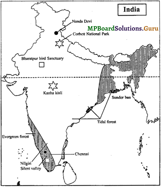
(1) Evergreen forest, Tidal forest, (2) Bharatpur bird Sanctuary and silent valley, (3) Kanha Kisli and corbett National park (2009), (4) Nandadevi, Nilgiri, Sundervan forest, (5) Kaziranga Park (2009), (6) Tidal Forest and Chennai. (MP 2009)
Answer:
Question 9.
Show the following on the map of India:
(1) Jammu and Kashmir, (2) Assam, (3) Karnataka, (4) Gujarat, (5) Madhya Pradesh (MP 2011)
Answer:
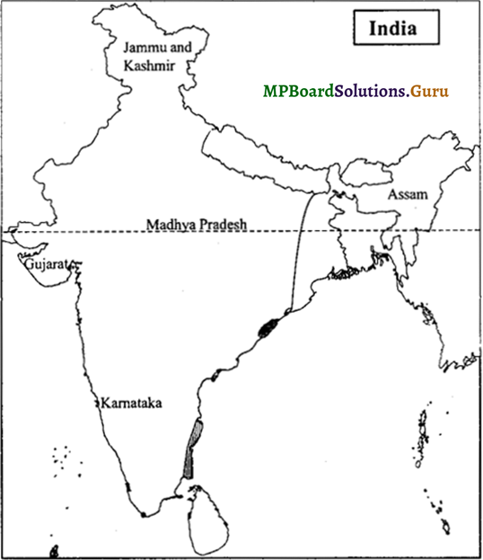
![]()
Question 10.
Show the following on the map of India:
(1) Tropical Evergreen forests and Tidal forests.
(2) Bharatpur Bird Sanctuary and Silent valley.
(3) Kanha-Kisli and Corbett National Park.
(4) Nanda Devi (2008), Nilgiri (2008, 09) and Sundarvan Biosphere Reserves, Bandhavagarh National Park (2008).
Answer:
I. Choose the correct alternative:
Question 1.
Which element is related in proportion to distance in a map:
(a) Scale
(b) Use of colour
(c) Grid of latitudes and longitudes
(d) Use of conventional signs
Answer:
(a) Scale
Question 2.
Which is not a type of map:
(a) Physical map of Kerala
(b) Political map
(c) Sketch map of India
(d) Distribution map
Answer:
(c) Sketch map of India
Question 3.
Which scale is representative Fraction (RF):
(a) One inch is equal to 10 miles
(b) 1 cm = km
(c) One cm for ten km
(d) 1 : 10,000
Answer:
(d) 1 : 10,000
Question 4.
Conventional signs are certified by:
(a) Central information department
(b) Indian constitution
(c) Survey department
(d) Parliament of India
Answer:
(c) Survey department
![]()
II. Fill in the blanks:
Question 1.
A map cannot be drawn without a …………..
Answer:
scale
Question 2.
The height of any place can be studied from …………..
Answer:
sea level
Question 3.
The topographical features like mountains, plateau, etc. are shown by …………. signs.
Answer:
conventional
Question 4.
A list of conventional sign in released by ………….. department.
Answer:
survey
Question 5.
Scale of a map is also indictated by a fraction called representative …………..
Answer:
fraction
III. Match the following: (MP 2011)
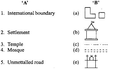
Answers:
1. (c)
2. (a)
3. (b)
4. (e)
5. (d)
![]()
IV. Write ‘true’ or ‘false’:
Question 1.
Reading of map is an art.
Answer:
True
Question 2.
On map arrows show the direction.
Answer:
True
Question 3.
Map scale is represented in R.F. with linear scale in standard units.
Answer:
True
Question 4.
Mountains, plains and plateaus are shown by conventional signs.
Answer:
True
Question 5.
The height of the contour lines is measured from the mean mountain level.
Answer:
False
![]()
V. Give answers in one word:
Question 1.
Collection of various maps.
Answer:
Atlas
Question 2.
An elevated track of comparatively flat or level land is called.
Answer:
Plateau
Question 3.
A grid of latitudes and longitudes drawn according to scale and rules.
Answer:
Projection
Question 4.
An elongated depression between the hills, with a river flowing at the base.
Answer:
Valley
Question 5.
Steep slope in the upper part and less slope in the lower part.
Answer:
Concaveslope